
5 Best Hikes near San Francisco
One of my favorite things to do when I’m home for a weekend is hike. Living in the Bay Area, most hikes afford amazing views of either the ocean, the bay, or the hills and mountains to the east. Here are five not to be missed, whether you are a local or just visiting!
The “Go-To” hike: Seaview Trail, Tilden Regional Park, Berkeley
If I don’t want to have to pack a lot of water or snacks, I do Seaview Trail in Tilden Regional Park. Right behind the city of Berkeley and up in the hills, Tilden park has many great hikes to choose from. What is fantastic about Seaview is that it’s easily accessible, has amazing views in every direction of San Francisco Bay and the East Bay hills, and allows for the interconnection of multiple trails if you want to expand or shorten your hike. Park at the Quarry trailhead and go up Seaview to the left, come back down Upper Big Spring, and cut over on the Quarry trail. The loop is 3.5 miles roundtrip. A park map can be found here.

The “Hills are alive” hike: Old Briones trail, Briones Regional Park, Walnut Creek
If I have time for more of a drive, a simple favorite is Briones Regional Park near Walnut Creek. There are rolling hills unlike anywhere I have ever seen. Park in the Bear Creek staging area and do a loop starting at the Old Briones Road Trail. Follow it to the Valley Trail, followed by Briones Crest, Mott Peak, then return on the Abrigo Valley trail. This makes for a nice 5.5 mile loop, which can be cut shorter on connecting any of the crisscrossing trails. If you aren’t too sweaty, go shop in Walnut Creek’s amazing new Broadway Plaza afterward. A park map can be found here.

View fullsize

Views of the Hills in Briones Regional Park.
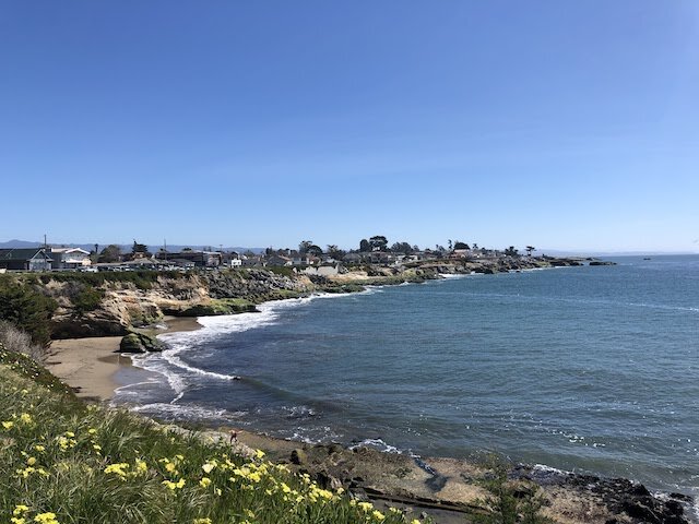
The “Ocean Air in my Hair” hike: Fort Cronkite, Golden Gate Recreational Area, Marin Headlands
Marin Headlands is a beautiful place to visit even if you don’t hike it. You can come for some vistas just to overlook the Golden Gate Bridge and the ocean, or you can visit the Point Bonitas Lighthouse to learn all about how ships enter into the San Francisco Bay from the ocean. Rodeo Beach is dog friendly, and the Marine Mammal Center is a feel good non-profit that rehabilitates sea creatures that will melt your heart. If that isn’t enough to fill your day, hike the coastal loop to take yourself on the bluffs above the ocean while getting to peek inside old World War II abandoned bunkers. Park anywhere along the lagoon/beach, then take the Coast Trail to the Wolf Ridge, then Milwok, and finish on the Lagoon Trail. It is 3.8 miles roundtrip, recommended going counter clockwise. Don’t forget to explore Hill 88 at the top! A park map can be found here.


The “Chasing Waterfalls” hike: Alamere Falls, Point Reyes National Seashore, Point Reyes
For the more athletic, Alamere falls is a real treat and best done trail running (because otherwise it gets crowded). Start at the Palomarin trailhead (warning: fills up early!) and run down to the beach, where at the end you will find a beautiful waterfall into the ocean. The last half mile meanders through some brush so make sure you wear long pants and sleeves to avoid exposure to poison oak. It is 4 miles each way (out and back). Park information can be found here.


Waterfalls into the ocean at the end of the Alamere Falls hike.
The “Quintessential I live in California and Love It” Hike: Dipsea/Steep Ravine/Matt Davis Loop, Mt. Tamalpais State Park, Mill Valley
You can’t go wrong on Mt. Tam, unless you show up too late in the day and can’t find parking. Otherwise, there are so many trails to choose from in many number of combinations. I recommend parking in the town of Stinson Beach. Then head up the Dipsea Trail, to Steep Ravine trail (famous for a ladder climb), then up past the Pantoll Ranger Station to the Upper Old Mine Trail (where we got engaged!), then back down to the Matt Davis Trail to the beach. Grab a late lunch at the Siren Canteen, where you can enjoy fish tacos with your feet in the sand. This is an approximately 6.8 mile roundtrip loop. A park map can be found here.


Marine layer and views for days from the Top of Mt. Tamalpais.
Are there any other incredible hikes I should have included in this list? Comment below!


I enjoyed reading your blog, thanks
I’m so glad! Thanks for reading.