
Tips for Hiking in Seoul’s Bukhansan National Park
Did you know that hiking is one of the main past times in South Korea? That’s because the country is home to many gorgeous national parks. One in particular, Bukhansan – is less than an hour outside of Seoul and easily accessed on public transit. That means you and throngs of Seoulites can enjoy a short (or long) hike in this amazing park to take in the natural beauty of South Korea. In this post, I’ll outline some tips for planning a Bukhansan National Park itinerary and provide some advice on Bukhansan hiking for beginners.
How to get there
The metro in Seoul is very easy to navigate, as are the buses. The main thing to keep in mind is if you need to buy a transit pass (the same pass can be used for all buses and trains). These passes can be purchased in most subway stations or in 7/11 convenience stores, and loaded with cash or card.
Depending on which hike you plan to do in Bukhansan, you will take different public transit. There are however many different bus and train systems on offer which guarantees you can get to your trailhead. Many people choose to start at the Seoul Hiking Tourism Center in Bukhansan.
The metro map can be accessed digitally, viewed in it’s entirety here or you can use Google Maps or Naver, a Korean specific mapping service.

What Bukhansan National Park is known for
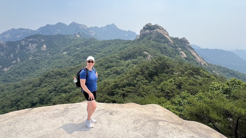
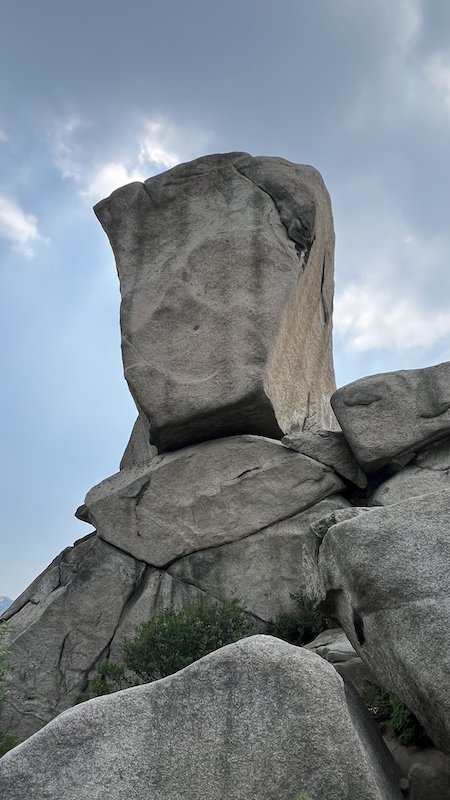
Aside from it’s easy access and proximity to Seoul, therefore providing a fantastic outlet for hiking lovers, Bukhansan offers beautiful streams, forested terrain, as well as unique rock formations with 360 views along various peaks in the park. Dotted among the trails you’ll also find stupas and buddhist temples, adding a rich cultural aspect to any hike. The hikes range in distance from 6km to 15km depending on the level of effort you want to exert, and the trails are well marked.
Safety
Please always come prepared for a hike, no matter how short. That means researching the route (and downloading it offline if possible), letting someone know where you are going, and carrying essentials with you like food, water and layers. Check out my 10 essentials hiking post for more information on how to best prepare yourself for any recreation in the outdoors.
Most popular hikes in Bukhansan
If you are curious about hiking in Bukhansan, I highly recommend visiting the hiking tourism office in Seoul (the google map pin can be found here). There is one right near Hanok Village between the two main castles in Seoul (i.e. the primary tourist area), and it’s a great place to pick up gear you might need (for rent or purchase), brochures and physical maps, as well as speak with a local who can advise you on which hike is best for you based on your skill level and the time you have available.
I have not personally done all of these hikes, but the ones I am including in this post are the most popular hikes and trails recommended by the Bukhansan Tourism ministry. This information can be found in more detail if you pick up a free Seoul Hiking Guidebook or Bukhansan National Park map at a tourism office. I’m outlining these trails as a starting point for reference – please also check AllTrails to confirm the full path. You can get a digital PDF of the English version of the guidebook for free here.
1. Baegundae-Ui Gugok Trail
Total travel distance: 9.98 km
Average travel time: 4 hours 20 minutes
Difficulty: advanced
This is the shortest trail up to Baegundae Peak, the summit of Bukhansan. The section from Haroojae Pass to Yeongbong Peak is extremely steep. Atop Yeongbong Peak at 604 meters, hikers are greeted by the majestic rock face of Insubong Peak. At the 836.5-meter-tall summit, a 360-degree panoramic view of Seoul unfolds. The closest match on Alltrails can be found here.

2. Bukhansanseong–Daenammun Trail
Total travel distance: 10.2 km
Average travel time: 4 hours 10 minutes
Difficulty: advanced
This trail marked by beautiful scenery and historical sites is a hikers’ favorite. It is also popular among foreigners as it passes through the main castle of the Bukhansanseong Fortress and historical palace sites. The wildflowers that bloom throughout the four seasons add to the beauty of the trail. The closest trail route on Alltrails can be found here.

3. Samobawi–Bibong Trail
Total travel distance: 6 km
Average travel time: 3 hours
Difficulty: advanced
This trail is optimal for enjoying the pristine mountain streams and blue skies on a clear day. On the trail is a monument commemorating the border inspection by King Jinheung of the ancient Silla Kingdom, as well as the path taken in 1968 by 31 North Korean commandos on their mission to assassinate South Korean President Park Chung-hee. The top of the trail offers an open panoramic view. The closest Alltrails option available can be found here.
4. Samcheonsa Trail
Total travel distance: 7.33 km
Average travel time: 2 hours 40 minutes
Difficulty: average
This trail starts and ends at Buddhist temples each more than 1,000 years old. Samcheonsa was founded in 661 during the Silla period and Jingwansa in 1011, during the Goryeo period. Seungabong Peak, the highest point on the trail, is named after Seungasa Temple that sits beneath it. The temples along the trail offer rest and peace of mind. The closest AllTrails option can be found here. I have also written a more extensive post about this hike in particular which you can check out.

5. Bukhansan Dulle-gil: Uiryeong-gil
Total travel distance: 6.42 km
Average travel time: 2 hour
Difficulty: easy
Uiryeong-gil is Section 21 of Bukhansan Dulle-gil Trail along unpaved paths between Bukhansan to the south and Dobongsan to the north. Public access to the path was restricted due to the thwarted 1968 mission by 31 North Korean commandos to assassinate South Korean President Park Chung-hee, but the path was reopened in July 2009 under a reservation system. The natural ecosystem on this path has been well preserved through about four decades of no human contact, and the gentle ascents and descents make Uiryeong-gil an easy walk. Find the Alltrails trail here.


