
4 days in Hardangervidda National Park
[Updated April 2025]
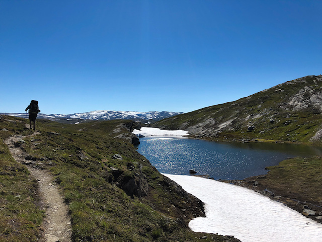
Norway is chock full of incredible nature to explore. On our trip, we devoted about 50% of our journey to backpacking through the incredible Hardangervidda National Park in the middle of the country. This high elevation plateau offered pristine lakes, snow covered mountains (and trails), sheep, and vast vistas of the rocky terrain. 98% of this national park falls above the tree line, and hiking in the summer means exposure to the strong Norwegian sun for 20 hours a day. Regardless, it was an incredible and challenging experience. An amusing recap is below.
If you are looking for a more serious post about logistics and how to repeat this hike, please check out my post on Backpacking to Norway’s Trolltunga in Hardangervidda National Park. And if you’re looking for more Norway travel advice, check out How to prepare for a hiking trip in Norway or my 1 day itinerary for Oslo.
In terms of how to prepare for the trip, I have a roundup of my go-to backpacking gear here, or you can check out my day hiking list. Finally, never leave home without your 10 essentials to recreate safely outside!
Day 1
11:15am: Hop off the bus in Kinsarvik and ask the man working the tourist office to point you in the direction of the trailhead. Get a little lost finding the trailhead anyway.

12:30pm: Realize you could have hitchhiked or taken a cab to the start of hike instead of hiking 3 miles, as you approach a parking lot full of cars. Somewhere off in the not-so-far distance you hear someone is firing a gun (hopefully just practicing their hunting skills), and you hope you don’t run into them on the trail.

3pm: You’ve hiked for a couple of miles and seen so many waterfalls, each more beautiful than the next. You’ve reached a crystal clear lake that you just can’t wait to dip your feet into. Norway is awesome.

6pm: You’ve lost the day hikers by now and have been wandering around on a large expanse of boulders with views of more waterfalls. The last hour or so you have been climbing straight up on less of a trail and more of a very steep mountainside with many fake summits. You think you are so close to where you wanted to end the hike that day when you reach the top, but it turns out you are still 3 miles away. Time to pitch a tent by a serene lake instead and have the place to yourself.

9pm: Fall asleep to the gurgling of the stream near your head and a small waterfall nearby. This place is perfect.
Day 2
7am: Wake up more rested than you’ve been in ages. It’s amazing when the white noise machine in your life is nature. Say hi to the sheep who are wandering around 30 feet from your tent and having a delicious breakfast of free-range Norwegian grass.
11am: Finally make it to the cabin you planned to camp near the night before. Be glad that you slept on your own, until you realize this cabin has cold beer and a hot tub! In the wilderness! What is this magical country? A friendly Norwegian family volunteering at the cabin sells you the best and most expensive bag of potato chips and soda you’ve ever enjoyed in the middle of nowhere from the pantry. Ponder to yourself about all the bags of potato chips that have ridden on helicopters more frequently than you.

5pm: You’ve spent the whole day hiking without seeing another soul. It’s just you and endless alpine lakes, snow-capped ridges in the distance, and many sheep. You wonder how the sheep find their way home in this vast national park by themselves.
9pm: You keep thinking you are only a mile away from the next cabin, but you aren’t. Serious exhaustion starts to set in, and you hunker down on the edge of a glacier-fed lake. You take a hobo shower in its icy cold waters and go to bed.

Day 3
6:30am: Wake up to the rumble and crash of a large piece of snow falling into the lake off of the glacier. Unzip the tent quickly and watch in horror, as your eyes adjust to the bright Norwegian morning, a tidal wave crossing the lake from where the snow fell, slowly approaching you. Sigh in relief as the water laps the shores and you and all your worldy belongings don’t get soaked.
8am: It turns out you were quite close to the next cabin. You had been dreaming of a hot buffet breakfast or cold beer waiting for you at this one but it turns out it is “self service” which means there is no pantry or volunteers. Oh well, at least it is beautiful here, and other hikers exist! With their dogs!

11:30am: The last few hours have been more technical than the first 2 days put together. You have scrambled and jumped over rocks, waded through streams, and started walking on a lot more snow. You have finally arrived at the plateau.
2pm: You swear you will never eat another Clif bar again. Unfortunately, you packed about nine of them and not much else for trail snacks. Rookie move. You suspect they are giving you very bad heartburn. You dream of eating something that wasn’t dehydrated first.
5pm: After hitting a fork in the trail, you finally start seeing hikers coming the other direction. Also, 50% of the last few hours have been spent hiking across snow covered trail. You pat yourself on the back for buying those last minute powder bins for your hiking poles and bringing your crampons all this way… except that the crampons are packed at the bottom of your bag.

7pm: You’ve made it to the third and final cabin on the trail. You get excited to see that there are sundries, which somehow include cheese. Cheese it is. You cook dinner and feel fueled with energy to get to the highlight of the hike, Trolltunga, by midnight!

8pm: Promptly lose the trail. It appears many of the obvious red “T’s” painted on cairns have been washed out or snow covered. You need to backtrack to find the trail again.

8:30pm: Have a minor panic attack as you realize you have to jump down 10 feet onto a ledge near the top of a waterfall, and then hop along some rocks to continue on the trail.
8:33pm: All good. You survived the jump! Become acutely aware of your own mortality and the realization that your dog would never survive this hike. They must breed those Norwegian dogs differently.
11pm: Wonder at the splendor of the universe as you watch the setting sun create the most beautiful sky against the backdrop of the mountains. You are alone in the middle of nowhere. Backpacking is the best!

11:45pm: Trolltunga… it has to be around here somewhere. Okay. You give up and make camp on the first dry rock you see. You have been hiking for 15 hours and your eyes are playing tricks on you, since this weird cloudy dusk is about as close to nighttime as you’ve encountered in 6 days. Goodnight.
Day 4
7am: You thought you were all alone in the middle of nowhere the night before. Then you wake up and walk towards Trolltunga and realize… you were never really alone. All these other people camped out on the top of this cliff too!

8am: Take a million pictures of all the beautiful things. Go back to camp and have some breakfast.

9am: Leave Trolltunga, but not without one more picture. However, now there is a line 25 people deep trying to take photos on the iconic spot. Pat yourself on the back for waking up early.

12pm: You thought the last day of this hike would be all downhill. It’s not. Not at all. You conclude trail elevation profiles are useless. However, you realize complaining is ridiculous because you are faced with another beautiful vista at every turn of the trail. Wonder to yourself why more people don’t make hiking a priority.

4pm: You have finally made it to the bottom. Unfortunately, the last 3 miles were on a steep paved road not on the trail map. But there is beer, ice cream, and waffles at the bottom area while you wait for your shuttle to Odda, where you have an Airbnb and a real bed waiting for you. Congratulations, you survived!


Beautiful and nice writing. I think I’m subscribed but I didn’t get an email for this one. Hope you are doing well!
-emile
Thanks! This is an older post I updated recently. Appreciate your readership!
Very nice read, thanks for this summary! Could I ask what time of year you went on this hike? Curious about all the snow 🙂
And, by any chance, wouldn’t you have more precise locations of the first two tent spots? They look just gorgeous by the lakes!
Thanks a lot and happy hiking!
-anna
We were there late June / early July. Sorry I don’t have more specific locations – we actually struggled with good digital maps of the area. Highly recommend if you go to pick up a physical map at the visitor center and talk to someone directly! Good luck 🙂
Great post! Im planning a trip there soon so i will look into the route you took. Here is a great map for all trails in Norway:https://ut.no/kart